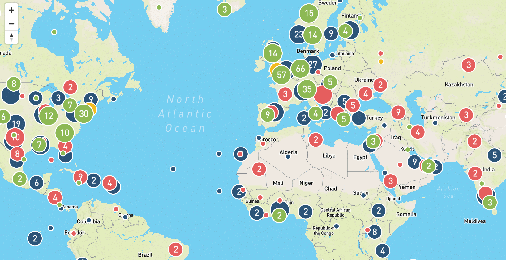
The world map documents geoengineering development research, experiments and projects
Climate geoengineering refers to large-scale schemes for intervention in the earth’s oceans, soils and atmosphere with the aim of reducing the effects of climate change, usually temporarily. The Interactive World Map on Geoengineering Research Projects and Experiments, prepared by the Heinrich Böll Foundation and ETC Group , sheds light on the alarming expansion of geoengineering research and experimentation. It builds on an earlier map of Earth Systems Experimentation published in 2012. That original map documented around 300 projects and experiments related to the field of geoengineering. Almost a decade later, more than 1,600 such projects have been identified – including past, ongoing and planned ones. However, there are no complete records of geoengineering projects, so this map is necessarily incomplete. While the proposed geoengineering approaches differ, they all have commonalities:
- The proposed geoengineering technologies exist only hypothetically as climate technologies – none has a track record of actual impact at the climate level.
- All proposed geoengineering approaches are associated with great risks and unknowns, e.g., for the abiotic and biotic environment as well as for communities.
- The proposed geoengineering technologies do not help to address the root causes of climate change, but function to delay the phase-out of fossil fuels or even intensify the production of fossil fuels and other extractive activities.
The interactive world map on geoengineering provides an overview of and insights into existing, planned, completed, and cancelled geoengineering projects, experiments, and research. For clarity, the registered geoengineering projects in the map are assigned to four different technical categories:
- Greenhouse gas removal (GGR) refers to a set of proposed technologies that aim to remove greenhouse gases from exhaust gases and the atmosphere, eg. BECCS and DAC, and also includes capture and use technologies such as CCS and CCUS.
- Solar radiation management (SRM) describes a suite of theoretical proposals that aim to reflect solar or thermal radiation back into space before it further warms the Earth’s climate.
- Weather modification (WM) refers to various techniques, such as cloud seeding, that seek to alter local or regional weather and precipitation patterns, but not overall climate patterns.
- The category “Other” includes major research projects, projects that aim to capture CO2 with algae, and other geoengineering projects that do not fit into any of the previously mentioned categories.
More background on the proposed geoengineering approaches can be found here.
Map category: Greenhouse Gas Removal (GGR)
The map category greenhouse gas removal (GGR) includes a set of proposed technologies that aim to remove greenhouse gases (GHGs) from the atmosphere. The technical approaches vary widely and span the removal of GHGs from exhaust gases, ambient air, and the marine environment:
Artificial upwelling and ocean fertilization are proposed GGR technologies that aim to capture GHGs in marine environments. Both technologies are associated with, among other hazards, major risks to the marine environment and fisheries. The map therefore lists all trials that serve to further develop both technologies and potentially lead to larger-scale trials.
Enhanced weathering attempts to remove CO2 in marine, coastal and terrestrial environments. Large-scale deployment would lead to major environmental harms. Therefore, the map informs on experiments aimed at further promoting this technology. It also covers commercial activities of companies that are trying to commodify enhanced weathering despite the unpredictable risks to ecosystems and a very dubious overall emissions balance.
Carbon capture and storage (CCS) and Carbon capture use and storage (CCUS) are technologies that are a basic component of many geoengineering technologies. The scale at which they are currently envisioned in many of the climate models makes them geoengineering as such. CCS aims to capture CO2 emitted by industrial processes such as fossil-fuel combustion, compress the captured CO2, and inject it into geological formations, theoretically, for long-term storage. The map contains all stages of CCS: privately and publicly funded industrial sites with CO2 capture, terrestrial and marine sites where CO2 is injected underground, along with sites where captured CO2 is used for Enhanced Oil Recovery or “stored”. However, the map also includes industrial projects and companies that further develop and market CCS technologies as well as some networks and laboratories that promote and research CCS very actively. CCUS aims to further process CO2 captured from exhaust gases or ambient air, e.g., to produce fuels, plastics or building materials. This basically only postpones the emissions. The map displays companies that develop and market CCUS, as well as companies where CCUS technology is applied. The map also identifies whether these projects are supported with industrial or public funding, as far as information on this is made publicly available.
Direct air capture (DAC) aims to capture CO2 from ambient air. Companies attempting to commercialise DAC technology are shown on the map, as are all projects that are implementing or planning to implement DAC, or that aim to reduce the significant costs of DAC, often in conjunction with public funding.
Bioenergy with carbon capture & storage (BECCS) is a theoretical GGR approach that aims to burn large quantities of cultivated crops, trees or plant residues, e.g., to generate energy, capture the emitted CO2, and “store” it through either CCS or CCUS. Given the extensive environmental and social problems associated with BECCS, small-scale projects that seek to test, further develop or apply BECCS are also mapped – partly because they prepare for larger-scale BECCS projects and partly in order to consider cumulative impacts.
Biochar is another proposed GGR approach that would consume very large amounts of biomass to influence climate change. The proposal involves processing biomass into a part-burned charcoal-like substance to be mixed into agricultural soils. The map covers information on biochar producers, pyrolysis technology developers and field trials. Given the large amounts of biomass required, smaller projects are included to account for cumulative effects and because many producers have big plans, such as the Australian Rainbow Bee Eater Pty Ltd, a small biochar producer that recently started selling carbon credits to Microsoft. Regional initiatives to promote biochar are also covered in the map.
Map category: Solar Radiation Management (SRM)
Solar radiation management (SRM) describes a suite of theoretical proposals that attempt to reflect solar or thermal radiation back into space so that it does not warm the Earth’s climate.
Stratospheric aerosol injections (SAI) aim to control the amount of incoming solar radiation. Due to the risks associated with SAI, the map offers data on institutions and companies seeking to advance the use of SAI through research, modelling and field trials.
Marine cloud brightening (MCB) and cirrus cloud thinning (CCT) are theoretical SRM approaches that aim to influence the Earth’s radiation balance through changes in cloud cover. The map contains entries on institutions that aim to advance the use of MCB and CCT through outdoor trials and modelling.
Proposals to generate long-lasting microbubbles and sea foam aim to increase the reflectivity of the sea surfaces or other bodies of water by creating tiny bubbles in bodies of water or by spreading foam on water surfaces. The map highlights institutions and companies that aim to advance these approaches by conducting research, modelling and commercialisation.
The proposals for high-albedo crops and snow forest clearance also aim to reflect more light back to space. The map lists the institutions where research groups explore and model these approaches.
Map category: Weather Modification (WM)
Weather modification (WM) refers to ground- and cloud-based technologies, such as cloud seeding, that intend to alter weather and precipitation patterns, but not overall climate patterns. WM attempts to increase or suppress precipitation, e.g., to counter droughts or to control precipitation on agricultural land. Because WM is thought to have only local or regional impacts, it is not often considered a form of geoengineering. However, WM technologies are important precursors of today’s geoengineering technologies, e.g., there are overlaps with SRM technologies, which also aim to release particles into the atmosphere. In addition to technological aspects, the experiences with and applications of WM are likely to be transferable to geoengineering technologies, both in terms of conflict and in terms of intertwining with military strategies and operations. Since even small-scale WM activities have already triggered conflicts, the map describes small- and large-scale WM activities, as far as data is available. After the World Meteorological Organization stopped its annual reports on World Cup activities in 2006, finding accurate data for WM has been difficult.
Map category: Other projects
Algae projects aim to use micro- or macroalgae to capture CO2 ; theoretically, the harvested algae could be used for the production of new products, including biofuels or animal feed. The map presents the known algae projects that seek to bind CO2.
The map category major research projects showcases the known projects and programmes that aim to advance geoengineering research. The projects model the use and potential of geoengineering, try to make geoengineering technologies more effective and less expensive, research the ecological impacts and social acceptance of geoengineering, and test geoengineering technology in laboratory and in outdoor trials. The thematic focus extends across the above-mentioned topics.
The category “Other” contains projects that do not fit into any of the previously mentioned categories. The spectrum ranges from projects that aim to dump CO2 in space, genetically manipulated plants supposed to store more CO2, proposals on how Arctic ice or glaciers should be restored, to competitions that seek to promote geoengineering, lobbying organizations that actively lobby for geoengineering out of commercial interest, and donors supporting geoengineering research, modelling and outdoor trials.
Where does the map’s data come from?
The data for the geoengineering map consists of several types of sources, including project-specific updates, relevant newsletters, scientific publications, data from funding agencies, available databases, and further sources.
As there are no complete records of geoengineering projects, the map is necessarily partial. Certainly, a number of projects will be missing. Nevertheless, the map is most likely the most comprehensive collection of data on geoengineering development research, experimentation, and development[8] .
Many geoengineering projects have their own websites, especially ongoing and planned projects. In the case of planned projects, it is often those that seek funding to conduct planned experiments or to commercialize their technology. In some cases, project-specific websites remain after projects were completed; these are usually publicly funded research projects, such as the pan-European research project MiReCOL. Information on completed, publicly funded research projects can often also be viewed retrospectively via a project database, e.g., the Cordis database of the European Commission. However, information is not available on all individual geoengineering projects; for example, industrial research projects are usually less transparent and some may not be made public at all. Other project websites are no longer active after project completion; this is often the case when a company was explicitly founded to commercialize a geoengineering technology and was not successful in doing so, such as the company AGG Biofuel. Some projects allow subscribing to a newsletter via their project website. For many other projects, updates can only be viewed directly on the project website or via websites of the project partners involved.
Scientific sources are mostly relevant for projects that are academically overseen, which are mainly projects in the category “major research project” or spin-offs from research institutions. The spectrum of scientific journals dealing with the topic of geoengineering has increased in recent years. Among them the International Journal of Coal Geology (CEPAC project, Brazil), the Chinese Academy of Sciences’ National Science Review (ONCE project, China), the American Chemical Society (sCS2 project, USA), Nature’s npj Materials Degradation (CarbFix project, Iceland), Mitigation and Adaptation Strategies for Global Change (DESARC-MARESANUS project, Italy), and many more. From time to time, there are additional pieces on geoengineering in scientific magazines, e.g., on Climeworks’ Direct Air Capture technology in Frontiers in Climate, studies on SRM in the Scientific African Magazine (DECIMALS project, South Africa) and in the Bulletin of the American Meteorological Society (Research on SRM, India).
Another important source of information, especially for new and ongoing project, are newsletters from associations and institutions involved or interested in geoengineering. The newsletters offer very different levels of information, from global to regional, and different content priorities. For example, the Global CCS Institute and the UK Carbon Capture and Storage Research Centre (UKCCSRC) provide information on Carbon Capture and Storage (CCS) projects, technologies and developments, while the International Biochar Initiative and the Australia New Zealand Biochar Industry Group (ANZBIG) present information on biochar issues. Other newsletters cover geoengineering projects or relevant technological developments occasionally, e.g., the newsletters of the Dutch Port of Rotterdam, the Australian Great Barrier Reef Foundation, the Norwegian Petroleum Directorate, the Algae Industry Magazine, Nanotechnology Now, the European Energy Research Alliance, and many others.
For some geoengineering technologies, there are also data collections that point to projects. Keyword searches in internet databases and online newspapers, newsletters on events and funding activities, newsfeeds from email groups, or keyword searches in different languages are also important sources of information, especially for new technological developments.
Disclaimer
The Interactive Worldmap on Geoengineering Research Projects and Experiments was created as a tool for activism for Environmental and Climate Justice. The map and related research intend to provide better availability of knowledge regarding geoengineering research projects and experiments. In addition, the map should make the geographical distribution of such projects and experiments more transparent and thus enable affected communities to resist geoengineering projects. Research that demonstrates a proven contribution to advancing environmental and climate justice, and where the researchers are engaged in dedicated research, will be privileged for data access.
Substantial efforts are made to ensure the accuracy of all information. However, the Heinrich Böll Foundation and ETC Group cannot guarantee that all information on this website is complete, accurate, and up-to-date. We warmly welcome comments on the accuracy of the data displayed; therefore, the information is subject to change without notice and may become outdated. If you notice any inaccuracies, dead website links, or have more information to add please contact us at anja@etcgroup.org.


